Other · Rhode Island
Westminster Arcade
Closed 2008. Reinhabited in 2013.
documented
most recently reopened its doors in October 2013 as a residential and commercial mixed-use building.
Solid = from the authors' map · outlined = public source · dashed = model-written, not yet reviewed by a person. Tap any value's source label to see where it came from. documented = a quoted excerpt (click to read it) · reported = a source named, no excerpt yet · no source.
Site profile22 elements · what this retrofit is built with · tap a chip for the evidence
Attention fading (Wikipedia views −40% y/y)
This site: 10,132 views, -44% wikimedia · all sites with this100k+ jobs within 45 min by transit
This site: 164,514 epa-walkability · all sites with this15-minute neighbourhood (5+ of 6 daily needs within 800 m)
This site: 6/6 openstreetmap · all sites with this200+ tax-credit housing units within 1 km
This site: 550 units in 6 properties hud-lihtc · all sites with this3+ other atlas sites within 10 km
This site: 3 within 10 km computed · all sites with this30,000+ vehicles a day on an adjacent road
This site: 51,200 on /006E21BX1 fhwa-hpms · all sites with thisBike network nearby
This site: 126 ways openstreetmap · all sites with thisCounty typical rent $2,000+
This site: $2,053/mo zillow · all sites with thisGrocery within 800 m
This site: 3 stores openstreetmap · all sites with thisHigh inland flooding risk
This site: Very High fema-nri · all sites with thisHigh natural hazard risk (FEMA NRI)
This site: Relatively High; inland flooding fema-nri · all sites with thisHigh social vulnerability tract (SVI ≥ 0.75)
This site: 0.81 cdc-svi · all sites with thisInterstate or freeway within 600 m
This site: /006E21BX1 fhwa-hpms · all sites with thisNational Register place within 500 m
This site: Federal Building; Union Trust Company Building nps-nrhp · all sites with thisOpportunity Zone
This site: 44007000800 hud-oz · all sites with thisRail within 800 m
This site: Providence openstreetmap · all sites with thisRenter-majority tract
This site: 88% census-acs · all sites with thisTract income up 60%+ since 2013
This site: +265% census-acs · all sites with thisWalkable block group (EPA ≥ 12)
This site: …index 19 epa-walkability · all sites with thisReinhabited
This site: …residential and commercial mixed-use building extraction · all sites with thisHousing
This site: …residential and commercial mixed-use building extraction · all sites with thisMixed use
This site: …residential and commercial mixed-use building extraction · all sites with thisNow
| Status | Operatingextracted, unreviewed documentedmost recently reopened its doors in October 2013 as a residential and commercial mixed-use building. |
|---|---|
| Strategy | Reinhabitedextracted, unreviewed documentedmost recently reopened its doors in October 2013 as a residential and commercial mixed-use building. |
| New uses | mixedextracted, unreviewed reported |
| What is there now | residential and commercial mixed-use buildingextracted, unreviewed documentedmost recently reopened its doors in October 2013 as a residential and commercial mixed-use building. |
| Retrofit year | 2013extracted, unreviewed reported |
| Redeveloper | Evan Granoff of Granoff Associates LLCextracted, unreviewed reported |
Site context
| Transit within 800 m | Providence (rail); 36 bus stops within 400 mOpenStreetMap |
|---|---|
| Motorway junctions within 2 km | 1A, 1B, 1C, 36AOpenStreetMap |
| FEMA flood zone | X · AREA WITH REDUCED FLOOD RISK DUE TO LEVEEFEMA NFHL |
| EPA-regulated facilities within 500 m | 66: ABERCROMBIE & FITCH; BANKBOSTON; BARR PHILIP DDS; BONANZA BUS LINES INC; BOSTON RADIATOR & BODY WORKS INCEPA FRS |
| Census tract 44007000800 | 4,931 people, 9,881 per sq mi; median household income $54,747; median gross rent $2,013; 88% renters; 7.2% vacant units; 7.6% commute by transitACS 2023 5-year |
| Walkability (EPA, block group) | index 19 of 20; 414 intersections per sq mi; nearest transit stop 59 m; land-use mix 0.66; 144,815 jobs within 45 min by car, 164,514 by transit; 39% of households without a carEPA Smart Location |
| Within a 10–15 minute walk (800 m) | 6 of 6 daily needs: 3 grocers, 8 schools, 90 parks or playgrounds, 2 health, 36 civic, 107 food and drink; 126 cycleway segments, 823 sidewalk-tagged segmentsOpenStreetMap |
| Opportunity Zone | yes, tract 44007000800 (rural)HUD |
| National Register places within 500 m | 15: Federal Building; Union Trust Company Building; Shepard Company Building; Shepard Company BuildingNPS |
| Housing permits, Providence County (RI), 2024 | 219 units in 5+ unit buildings, 249 in 2–4, 314 single-family; 2023: 196 in 5+Census BPS |
| Social vulnerability (CDC SVI 2022, tract) | overall percentile 0.81; socioeconomic 0.73; housing and transport 0.97; 32% below 150% of poverty; 43% of households with no vehicleCDC/ATSDR |
| Other atlas sites nearby | 3 within 10 km, 8 within 25 km: Providence Arcade (0.2 km); Mechanical Fabric Company (0.2 km); Davol Square Marketplace (0.8 km)computed |
| Overture Maps | no place match; building footprint 1,761 m², 11.656481742858887 mOverture (CDLA-Permissive 2.0) |
| Attention: Wikipedia page views | 119,981 since 2015; 10,132 in the last 12 months (-44% vs the prior 12); peak 2024-12 with 5,636Wikimedia |
| Tract change 2013–2023 | population +21% (4,084 → 4,931); median income +265% ($15,000 → $54,747); renters 98% → 88%; median home value +124% ($239,300 → $536,200)Census ACS 5-year |
| Natural hazard risk (FEMA National Risk Index, tract) | relatively high overall (score 86.1); expected annual loss $2.5M; high: inland flooding; community resilience relatively moderateFEMA NRI |
| Tax-credit housing within 1 km | 6 LIHTC properties, 550 units: Travelers Aid Housing (192 units); Grace Church Apts (100 units); Cathedral Square I (100 units)HUD LIHTC |
| Retail trade in the county, 2025 (BLS QCEW) | 23,726 jobs in 2,010 establishments; average annual pay $39,929; employment location quotient 0.83; employment -1.4% on the yearBLS QCEW 2025, NAICS 44-45, private |
| Jobs located in the tract, 2022 | 20,794 jobs; 1,507 in retail trade, 2,904 in accommodation and food (workplace blocks summed to tract 44007000800)Census LEHD LODES8 WAC 2022 |
| Upward mobility (Opportunity Atlas, 2010 tract) | children of low-income (25th percentile) families reached the 38th income percentile as adults; 1.3% incarcerated at the 2010 count (37 children in the sample); born 1978–83, measured 2014–15Opportunity Insights |
| Food access (USDA FARA 2019, 2010 tract) | not a low-access tract at 1 mile; poverty rate 38.2%; median family income $76,125; 603 SNAP householdsUSDA ERS |
| Schools | Providence School District (PK-12); 17 public schools within 1 mile: Urban Collaborative Program; Trinity Academy Performing Art; RINI Middle College; Sheila Skip NowellNCES EDGE |
| Elevation | 11 ft above sea level at the site pointUSGS 3DEP |
| Storm events in the county, 2016-2025 | 196 county-logged events: 86 thunderstorm wind, 42 flood, 38 flash flood, 10 hail; $2,852,800 property damage reported; forecast-zone events (most flood, winter and heat) not countedNOAA Storm Events |
| Homes for sale in ZIP 02903, 2026-09 | median list price $438,675 (-8.8% on the year); 33 active listings; median 44 days on market; 21% with a price cutRealtor.com Research |
| Retail trade in the county, 2012 to 2023 | 1,904 establishments (-5%); 25,964 jobs (+6%)Census CBP |
| Housing market in the county | typical home value $453,475 (+2% 1 yr, +32% 5 yr); typical rent $2,053/mo (+4% 1 yr), 2026-09Zillow Research |
| Traffic on the busiest road within 600 m (2024) | 51,200 vehicles a day on /006E21BX1 (freeway or expressway, 3 lanes); 2,908 trucks; 18 counted segmentsFHWA HPMS |
Summary, model-written
The Westminster Arcade opened in 1828 as a market and became the first enclosed shopping mall in the United States. It operated as a retail center for many years before declining in the late 20th century, closing for renovations in 2008. It reopened in October 2013 as a residential and commercial mixed-use micro-loft building and is currently operating.
Why. The record does not specify the causes of the arcade’s decline, such as anchor store losses, competition, debt, or demolition.
Where it stands. The arcade is currently operating as a mixed-use building under the control of Evan Granoff of Granoff Associates LLC.
For a planner
- Historic designation (National Register 1971, National Historic Landmark 1976) provides preservation framework and potential tax incentives.
- Adaptive reuse strategy classified as 'reinhabit' with new mixed‑use residential/commercial program.
- Open questions include long‑term market demand for micro‑lofts, ongoing maintenance costs for historic fabric, and any needed zoning adjustments.
For a developer
- Site control: Evan Granoff/Granoff Associates LLC; retrofit completed 2013, status operating.
- Entitlement stage: adaptive reuse already entitled and built; no further entitlement needed.
- Constraints: flood risk, transit access, environmental conditions, and exact site size are not stated in the record.
- Market signals: tract‑level demographics, housing demand, and vacancy rates are not provided.
What we do not know yet
- Key missing facts: site acreage or square footage, flood zone designation, proximity to transit, environmental constraints, and detailed tract‑level market data.
- Reasons for the late‑20th‑century decline are not explained in the record.
- Current occupancy, lease terms, and financial performance post‑retrofit are unknown.
- The record is marked as 'draft' (verified), indicating that extracted data may be unreviewed and could contain errors.
- Opposition reasons note retrofit already built and modest county growth, suggesting limited upside potential.
Generated by nvidia/nemotron-3-super-120b-a12b on NVIDIA API via Hermes CT from the fields, parcels, deals and context layers on this page, with no outside knowledge. It is regenerated when the record changes and has not been checked by a person. How it is made.
Similar sites
- Bandana Square, Saint Paul, MN · Malls · closed 2006; same strategy: reinhabit
- Rhode Island Mall, Warwick, RI · Malls · closed 2011; also in RI; 13 km away
- Springfield Mall, Springfield, VA · Malls · closed 2012; same strategy: reinhabit
- Town & Country Center, Arlington Heights, IL · Malls · closed 2004; same strategy: reinhabit
Elsewhere on the web
Pages with photos
- Westminster Arcade, Provid… flickr.com
- Westminster Arcade Providence Stock Photo - Alamy alamy.com
- Historic Mall Layout upload.wikimedia.org
- Westminster Arcade, Providence, RI – Lost New En… lostnewengland.com
- Westminster Arcade, America’s Oldest Shopping Mall, is Still Sta… adaptandreuse.com
- Westminster Arcade facade, Providence, Rhode Island, U.… researchgate.net

Search images: Google · Bing · Commons · references: ULI case studies · Google Scholar
Multifamily screen
- retrofit already built
- county grew 3.9% 2018–23
- housing in the record
Inputs: record fields (size, status) and county Census ACS 2018–2023 figures (growth, rent). How the points work. Not a recommendation.
History and original facts
| Closed | 2008extracted, unreviewed |
|---|---|
| Original developer | Cyrus Butlerextracted, unreviewed documentedThe Arcade was developed as a commercial business venture by Cyrus Butler. |
| Architect | Russell Warren and Tallman & Bucklin |
| County | Providence County |
| Census division | 1 · New England |
| Notes | Wikipedia categories: Defunct shopping malls in the United States |
Not yet recorded: acres, GLA, year opened. Know it? Tell us.
Background
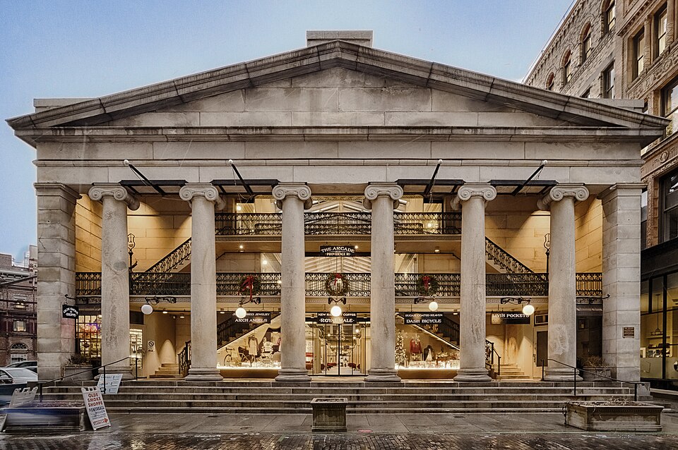
The Westminster Arcade is a historic shopping center at 130 Westminster Street and 65 Weybosset Street in downtown Providence, Rhode Island erected in 1828. It is notable as the first enclosed shopping mall in the United States and has been lauded as a fine example of commercial Greek Revival architecture. It served as a shopping center for many years before falling into decline in the late 20th century. It has since been closed for renovation and rehabilitation several times, and most recently reopened its doors in October 2013 as a residential and commercial mixed-use building. It was declared a National Historic Landmark in 1976.
Excerpt from Wikipedia (authors and history), CC BY-SA 4.0. May be older than the record above.
Timeline
- 1971 Listed on National Register of Historic Places
- 1976 Declared a National Historic Landmark
- 1980 Reopened after rehabilitation
- 2008 Closed for renovations
- 2013 Reopened as mixed-use micro-loft space
Sources
- Wikipedia: Westminster Arcade · supports: after notes, original developer, status, strategy, year closed
10 quoted sentences
It closed again in 2008 for renovations.
The Arcade was developed as a commercial business venture by Cyrus Butler.
most recently reopened its doors in October 2013 as a residential and commercial mixed-use building.
most recently reopened its doors in October 2013 as a residential and commercial mixed-use building.