Malls · Georgia
North DeKalb Mall
Opened 1965. Closed 2020. Redeveloped in 2023. Owner of record Ndm Edens LLC.
Solid = from the authors' map · outlined = public source · dashed = model-written, not yet reviewed by a person. Tap any value's source label to see where it came from.
Site profile19 elements · what this retrofit is built with · tap a chip for the evidence
Mervyn's
This site: Mervyn's wikipedia · all sites with thisRich's
This site: Rich's wikipedia · all sites with thisWoolworth
This site: Woolworth wikipedia · all sites with thisWebsite alive
This site: …https://www.edens.com overture / http check · all sites with thisSingle-purpose entity
This site: NDM EDENS LLC county-parcels · all sites with this15-minute neighbourhood (5+ of 6 daily needs within 800 m)
This site: 5/6 openstreetmap · all sites with this3+ other atlas sites within 10 km
This site: 9 within 10 km computed · all sites with this30,000+ vehicles a day on an adjacent road
This site: 75,500 on Stone Mountain Fwy; fhwa-hpms · all sites with thisGrocery within 800 m
This site: 3 stores openstreetmap · all sites with thisInterstate or freeway within 600 m
This site: Stone Mountain Fwy; fhwa-hpms · all sites with thisTract income up 60%+ since 2013
This site: +62% census-acs · all sites with thisWalkable block group (EPA ≥ 12)
This site: …index 13.7 epa-walkability · all sites with thisRezoning
This site: C-1 (Local Commercial) → MU-4 (Mixed Use High Density) (rezoning to MU-4 with a Master Development Plan) research-planning · all sites with thisTax increment financing
This site: …oning to MU-4 with a Master Development Plan) Market Square Tax Allocation District approved unanimously in 2022; amount not found. Edens paid research-planning · all sites with this60+ acre site
This site: 73.11 acres research-planning · all sites with thisRedeveloped
This site: …mixed-use: retail, ~1,800 homes, Publix record · all sites with thisGrocery
This site: …mixed-use: retail, ~1,800 homes, Publix Approved by DeKalb County Board of Commissioners (unanimous extraction · all sites with thisMixed use
This site: …mixed-use: retail, ~1,800 homes, Publix Approved by DeKalb County Boa extraction · all sites with thisRetail (continued)
This site: …mixed-use: retail, ~1,800 homes, Publix Approved by DeKalb County Board of Co extraction · all sites with thisNow
| Status | Demolishedextracted, unreviewed |
|---|---|
| Strategy | Redevelopedpublic sources |
| New uses | mixedextracted, unreviewed |
| What is there now | mixed-use: retail, ~1,800 homes, Publixpublic sources |
| Retrofit year | 2023public sources |
| Redeveloper | EDENS, Crescent Communitiespublic sources |
| Owner of record | Ndm Edens LLCcounty assessor |
Planning
| Zoning change | C-1 (Local Commercial) → MU-4 (Mixed Use High Density) (rezoning to MU-4 with a Master Development Plan)research |
|---|---|
| Public purchase or subsidy | Market Square Tax Allocation District approved unanimously in 2022; amount not found. Edens paid $43M for the site in Sept 2021.research |
| Entitlement year | 2022research |
| Planning notes | Approved by DeKalb County Board of Commissioners (unanimous). Master Development Plan, NDM (Edens), Z-24-1247113 staff report https://dekalbcountyga.gov/sites/default/files/2024-09/N4-2024-0900%20NDM%20%28EDENS%29%20Dennis%20J.%20Webb%20Z-24-1247113.pdfresearch |
Parcels, tax and title
| Parcel | Owner of record | Acres | Use · zoning | Value (appraised · assessed · taxable) | Last sale · deed | ||||||||||||||||||||||||||||||||||||||||||||||||||||||||||||||||||||||||||||
|---|---|---|---|---|---|---|---|---|---|---|---|---|---|---|---|---|---|---|---|---|---|---|---|---|---|---|---|---|---|---|---|---|---|---|---|---|---|---|---|---|---|---|---|---|---|---|---|---|---|---|---|---|---|---|---|---|---|---|---|---|---|---|---|---|---|---|---|---|---|---|---|---|---|---|---|---|---|---|---|---|---|
18 100 02 061all 35 county fields
| Ndm Edens LLC | 6.9 | TC · MU-4 | $7.1M (appraised) assessed $2.8M | — | ||||||||||||||||||||||||||||||||||||||||||||||||||||||||||||||||||||||||||||
18 100 02 005all 36 county fields
| Ndm Edens LLC | 5.2 | TC · MU-4 | $1.9M (appraised) assessed $777,200 | — | ||||||||||||||||||||||||||||||||||||||||||||||||||||||||||||||||||||||||||||
18 100 02 066all 35 county fields
| Ndm Edens LLC | 2.0 | TC · MU-4 | $3.5M (appraised) assessed $1.4M | — | ||||||||||||||||||||||||||||||||||||||||||||||||||||||||||||||||||||||||||||
18 100 02 058all 41 county fields
| Ndm II Edens LLC | 1.8 | TC · C-1 | $2.4M (appraised) assessed $978,400 | — | ||||||||||||||||||||||||||||||||||||||||||||||||||||||||||||||||||||||||||||
18 100 07 002all 33 county fields
| Sky Speed Distributors Inc | 0.7 | CRC · C-1 | $1.1M (appraised) assessed $448,600 | — | ||||||||||||||||||||||||||||||||||||||||||||||||||||||||||||||||||||||||||||
18 100 07 003all 34 county fields
| Executive Leasing Co | 0.7 | CRC · C-1 | $374,900 (appraised) assessed $149,960 | — | ||||||||||||||||||||||||||||||||||||||||||||||||||||||||||||||||||||||||||||
| Total | 17.3 | $16.4M |
What could be built herezoning code as encoded 2026-10-20 · indicative
| By right | Bonus density | Upzone | |
|---|---|---|---|
| District(s) | MU-4 14.07 ac (density 24 du/ac); C-1 3.24 ac (height × coverage) | MU-4 14.07 ac (density 40 du/ac); C-1 3.24 ac (height × coverage) | MU-5 14.07 ac (density 40 du/ac); MU-4 3.24 ac (density 24 du/ac) |
| Storeys / height | 4 / 60 ft | 6 / 75 ft | 6 / 75 ft |
| Envelope (height × coverage), sq ft | 2,448,156 | 3,551,357 | 3,817,683 |
| Program within density cap, sq ft | 619,757 | 872,882 | 716,625 |
| Homes at 900 sq ft | 336 | 561 | 637 |
| Non-residential, sq ft | 317,357 | 367,982 | 143,325 |
| Parking spaces (code minimum) | 1,139 | 1,577 | 1,242 |
| Surface acres those spaces need | 9.2 | 12.7 | 10.0 |
| Proxy NOI / year | $3.9M | $6.6M | $7.4M |
| Proxy NOI on county appraised value | 24% | 40% | 45% |
| County appraised value per home | $49k | $29k | $26k |
Parcel by parcel, what moves the number, assumptions
| Parcel | Address | Owner of record | Acres | Zoning | Character area | County appraised | Homes by right | Homes bonus | Homes upzone | What binds |
|---|---|---|---|---|---|---|---|---|---|---|
18 100 02 061 | 1041 Mysterious Way Decatur, GA 30033 | NDM Edens LLC | 6.86 | MU-4 | Town Center | $7.1M | 164 | 274 | 274 | density 24 du/ac |
18 100 02 005 | 2710 Lulah Avenue Decatur, GA 30033 | NDM Edens LLC | 5.17 | MU-4 | Town Center | $1.9M | 124 | 206 | 206 | density 24 du/ac |
18 100 02 066 | 2791 Lulah Avenue Decatur, GA 30033 | NDM Edens LLC | 2.04 | MU-4 | Town Center | $3.5M | 48 | 81 | 81 | density 24 du/ac |
18 100 02 058 | 2136 Lawrenceville Highway Decatur, GA 30033 | NDM II Edens LLC | 1.83 | C-1 | Town Center | $2.4M | 0 | 0 | 43 | height × coverage |
18 100 07 002 | 2125 Lawrenceville Highway Decatur, GA 30033 | Sky Speed Distributors INC | 0.72 | C-1 | Commercial Redevelopment Corridor | $1.1M | 0 | 0 | 17 | height × coverage |
18 100 07 003 | 2113 Lawrenceville Highway Decatur, GA 30033 | Executive Leasing Co | 0.69 | C-1 | Commercial Redevelopment Corridor | $375k | 0 | 0 | 16 | height × coverage |
Owner of record and appraised value from the county assessor as retrieved; natural persons are withheld. Appraised value is the assessor's figure, not a price or an opinion of value.
- MU-4 bonus density. Bonus density path, same district: Table 2.22 raises Town Center / Regional Center density from 24 to 40 du/ac (Sec. 27-2.22.1); Table 2.11 'Density 24 to 40' row, building with accessory non-residential, 6 stories or 75 ft. Bonus density is conditional on the district's bonus provisions (Sec. 27-2.22.1); the conditions are not modelled.
- C-1 bonus density. No bonus density: multi-family not permitted (Table 2.24). Height above 2 stories needs a Special Land Use Permit (Table 2.24 footnote 5); not modelled.
- C-1 residential. Table 2.24: multi-family attached dwelling 'Not permitted' in C-1; live/work unit permitted (residential portion min 650 sq ft)
- MU-4 density. Table 2.22: Town Center and Regional Center base 24, bonus 40; Office Park and Highway Corridor base 24, bonus 30
- MU-5 density. Table 2.23: Town Center base 40, bonus 60; Regional Center base 40, bonus 120
- Parking. Code minimums are shown (DeKalb Table 6.2: 1.5 spaces per home, 1 per 500 sq ft retail). A shared-parking reduction (Table 6.3) and structured parking both shrink the surface acres; neither is modelled.
Covers 17.3 of 73.1 site acres: the 6 assessor parcels within 40 m of the pin that carry a zoning code. parcel outlines from the county parcel layer. Parcel outlines: DeKalb County Property Appraisal Parcels_IASWorld FeatureServer/0. Homes at 900 sq ft average; 350 sq ft per surface space; proxy NOI = homes × rent × 12 × 92% occupancy × (1 − 40% opex), rent = Zillow ZORI, county 13089, 2026-09 (housing_market layer, retrieved 2026-10-20); commercial income not estimated. Bonus density = the same district at its bonus density and the matching height row. Upzone = the county's next mixed-use district as listed in the rule table (MU-4 → MU-5; C-1/C-2 → MU-4), not a proposal. bonus density is conditional on the district's bonus provisions; conditions not modelled; character area Commercial Redevelopment Corridor: 'all other' coverage 80%; coverage not set for multi-family; 1 − 10% open space used; surface parking does not fit beside the footprint; structured or shared parking implied. Code sections: MU-5: Sec. 27-2.23.1 and Table 2.23, Sec. 27-2.18.3 Table 2.17, Sec. 27-2.16.6 Table 2.13, Sec. 27-6.1.4 Table 6.2; C-1: Sec. 27-2.26.3 (dimensions by reference), Sec. 27-2.24.1 Table 2.24, Sec. 27-6.1.4 Table 6.2; MU-4: Sec. 27-2.22.1 and Table 2.22 (density, height reference), Sec. 27-2.18.3 Table 2.17 (dimensions, open space, mix of uses, setbacks), Sec. 27-2.15.6 Table 2.11 (height by density), Sec. 27-6.1.4 Table 6.2 (parking). Sources: MU-5 · C-1 · MU-4. JSON.
Request the full scheme site plan options, phasing, parking and yield by scenario, with the code citations: early access.
All covered sites →Deals and debt
| Date | Event | Price | Parties | Source |
|---|---|---|---|---|
| 2019 | Sold | — | Edens | Wikipedia |
| 2014 | Sold | — | Lennar in partnership with Sterling Organization | Wikipedia |
| 2003 | Sold | $25.0M closed | Hendon Properties | Wikipedia |
Securitised debt and public filers
Filings (2001 to date) that name “North DeKalb Mall” and “Decatur” (5 hits, first 5 sampled, 1 other filers such as tenants left out). Only weak matches to commercial-mortgage trusts: the mall may have backed a securitised loan, or may just be mentioned in the filing; several trusts usually means one loan split into pari-passu notes. Earliest trust filing in the sample 2004-11-09 (a sample date, not the issuance date); candidate loan vintage 2004 from the trust name (weak match). Whether the loan is still in the pool, in special servicing or repaid is in the trust's monthly distribution reports, which are not searchable here. Text matches, not a title search. Open the search · all trusts.
| Kind | Filer | Filings | Dates | Forms |
|---|---|---|---|---|
| CMBS trust (weak) | LB-UBS Commercial Mortgage Trust 2004-C7 | 2 | 2004-11-09 to 2004-12-17 | 8-K 1, 8-K/A 1 |
Site context
| Transit within 800 m | no rail stationOpenStreetMap |
|---|---|
| Motorway junctions within 2 km | 1, 2, junctionOpenStreetMap |
| FEMA flood zone | X · AREA OF MINIMAL FLOOD HAZARDFEMA NFHL |
| EPA-regulated facilities within 500 m | 12: B&D AUTO AIR; BUILDERS SQUARE #1493; EXXON FOOD STORE; JIFFY LUBE STORE #136; JOE MAY VALET CLEANERSEPA FRS |
| Census tract 13089022302 | 4,237 people, 3,130 per sq mi; median household income $95,847; median gross rent $1,954; 40% renters; 9.0% vacant units; 3.1% commute by transitACS 2023 5-year |
| Walkability (EPA, block group) | index 13.7 of 20; 73 intersections per sq mi; nearest transit stop 519 m; land-use mix 0.65; 223,387 jobs within 45 min by car, 86,554 by transit; 8% of households without a carEPA Smart Location |
| Within a 10–15 minute walk (800 m) | 5 of 6 daily needs: 3 grocers, 1 schools, 4 parks or playgrounds, 0 health, 1 civic, 12 food and drink; 0 cycleway segments, 20 sidewalk-tagged segmentsOpenStreetMap |
| Opportunity Zone | noHUD |
| Housing permits, DeKalb County (GA), 2024 | 385 units in 5+ unit buildings, 0 in 2–4, 853 single-family; 2023: 1,563 in 5+Census BPS |
| Social vulnerability (CDC SVI 2022, tract) | overall percentile 0.32; socioeconomic 0.22; housing and transport 0.52; 17% below 150% of poverty; 8% of households with no vehicleCDC/ATSDR |
| Other atlas sites nearby | 9 within 10 km, 63 within 25 km: Northlake Mall (4.7 km); Avondale Mall (5.8 km); Belvedere Plaza (6.0 km); Buford Clairmont Mall (6.9 km); East Lake Meadows (6.9 km)computed |
| Overture Maps | place Lulah Hills (shopping_mall, confidence 0.95, from BrightQuery, Overture, Overture-signals)Overture (CDLA-Permissive 2.0) |
| Website and social | www.edens.com (alive)Overture / Internet Archive |
| Attention: Wikipedia page views | 70,286 since 2015; 5,031 in the last 12 months (-30% vs the prior 12); peak 2024-06 with 3,244Wikimedia |
| Tract change 2013–2023 | population -7% (4,549 → 4,237); median income +62% ($58,977 → $95,847); renters 51% → 40%; median home value +92% ($228,000 → $437,500)Census ACS 5-year |
| Natural hazard risk (FEMA National Risk Index, tract) | relatively low overall (score 34.8); expected annual loss $1.1M; community resilience relatively lowFEMA NRI |
| Tax-credit housing within 1 km | 1 LIHTC properties, 168 units: Cedar Creek Apts (168 units)HUD LIHTC |
| Retail trade in the county, 2012 to 2023 | 2,187 establishments (-1%); 32,286 jobs (+6%)Census CBP |
| Housing market in the county | typical home value $332,528 (-2% 1 yr, +9% 5 yr); typical rent $1,764/mo (+2% 1 yr), 2026-09Zillow Research |
| House price index, tract, 2025 | 582 (2000 = 100); -1.3% 1 yr, +35% 5 yr, +84% 10 yrFHFA |
| Traffic on the busiest road within 600 m (2024) | 75,500 vehicles a day on Stone Mountain Fwy; (freeway or expressway, 5 lanes); 1,770 trucks; 39 counted segmentsFHWA HPMS |
| Site metrics | appraised value $16.4M on parcels; $224,864 per acre; 8,686 sq ft GLA per acre; FAR 0.2computed |
Summary, model-written
North DeKalb Mall opened in 1965 with anchors Rich's and Woolworth, expanded in 1986 adding Mervyn's and Lechmere, and underwent multiple anchor changes through the 1990s and 2000s. The mall closed in 2020 due to poor sales and the COVID‑19 pandemic, was demolished in 2024, and is currently being redeveloped as the mixed‑use Lulah Hills project.
Why. The closure resulted from anchor store losses (Mervyn's, Macy's, etc.), declining sales, and the impact of the COVID‑19 pandemic, as noted in the record. No explicit debt or other financial causes are stated.
Where it stands. The site is demolished and under redevelopment by EDENS and Crescent Communities (via NDM EDENS LLC) as of 2023, with the Lulah Hills mixed‑use project underway.
For a planner
- Rezoning from C‑1 (Local Commercial) to MU‑4 (Mixed Use High Density) with a Master Development Plan approved unanimously in 2022.
- Use of the Market Square Tax Allocation District (approved 2022) as a public subsidy tool, though the exact amount is not disclosed.
- Open questions include the precise subsidy amount, timeline for delivery of the ~1,800 housing units, and any required infrastructure improvements.
For a developer
- Site size: 73.11 acres with 635,000 sf GLA; current FAR 0.2 and total parcel value $16,439,800.
- Control: EDENS and Crescent Communities acquired the property in 2019 and are leading the redevelopment (parcels owned by NDM EDENS LLC).
- Entitlement stage: zoning changed to MU‑4 in 2022; entitlement year recorded as 2022, indicating approved development rights.
- Constraints: record does not specify floodplain, transit access, or environmental limitations; these would need verification.
- Market signals: median rent $1,591 (from opp_reasons) and planned ~1,800 residential units indicate strong housing demand in the area.
What we do not know yet
- Exact amount of the Market Square Tax Allocation District subsidy is not found in the record.
- Details on flood risk, environmental review, or transit proximity are absent.
- Timeline for completion of demolition and vertical construction is not specified.
- Financing structure (debt/equity) for the redevelopment is not disclosed.
- The record’s verification status is 'draft', indicating some facts may be model‑extracted and unreviewed.
Generated by nvidia/nemotron-3-super-120b-a12b on NVIDIA API via Hermes CT from the fields, parcels, deals and context layers on this page, with no outside knowledge. It is regenerated when the record changes and has not been checked by a person. How it is made.
Similar sites
- Cottonwood Mall site, Holladay, UT · Malls · similar size (57 acres); similar GLA (730,000 sq ft); opened 1962
- Crossroads Mall, Omaha, NE · Malls · similar GLA (717,272 sq ft); opened 1960; closed 2020
- Lafayette Square Mall, Indianapolis, IN · Malls · similar size (80 acres); opened 1968; closed 2022
- Monmouth Mall, Eatontown, NJ · Malls · similar size (64 acres); opened 1960; closed 2024
Elsewhere on the web
Pages with photos
- North Dekalb Mall: Decatur, GA skycity2.blogspot.com
- North DeKalb Mall Rebuild Plans Slowly Progressing | Decatur, GA … patch.com
- North DeKalb Mall Macy's flickr.com
- North Dekalb Mall Amc North Dekalb Mall - Cars Wallpaper car.sejarahperang.com
- North DeKalb Mall will be Lulah Hil… pasttensega.com
- Tomorrow's News Today - Atlanta: [SPECIAL] A Look at the Past, Prese… tonetoatl.com
- NORTH DEKALB MALL - Updated July 2026 - 60 Reviews - 2050 Lawrenceville ... yelp.com
- Champs North Dekalb Mall | Preliminary site plan release… printandproof.co.uk
Search images: Google · Bing · Commons · references: ULI case studies · Google Scholar
Multifamily screen
- retrofit already built
- closed or demolished site (sourced)
- already in play: under construction, approved, or sold to a developer with housing plans
- 73.11 acres
- median rent $1,591
- housing in the record
Inputs: record fields (size, status) and county Census ACS 2018–2023 figures (growth, rent). How the points work. Not a recommendation.
History and original facts
| Now called / also known as | Lulah Hills |
|---|---|
| Opened | 1965Wikidata |
| Closed | 2020extracted, unreviewed |
| Acres | 73.1research |
| Gross leasable area | 635,000 sq ftresearch |
| Original developer | Scott Developmentresearch |
| Architect | Barrett + Associates, Architects |
| Anchors | Phar-Mor, Lechmere, Rhodes Furniture, Marshalls, Mervyn's, Woolworth, Rich's, Uptons, AMC movie theater |
| County | DeKalb County |
| Census division | 5 · South Atlantic |
Background
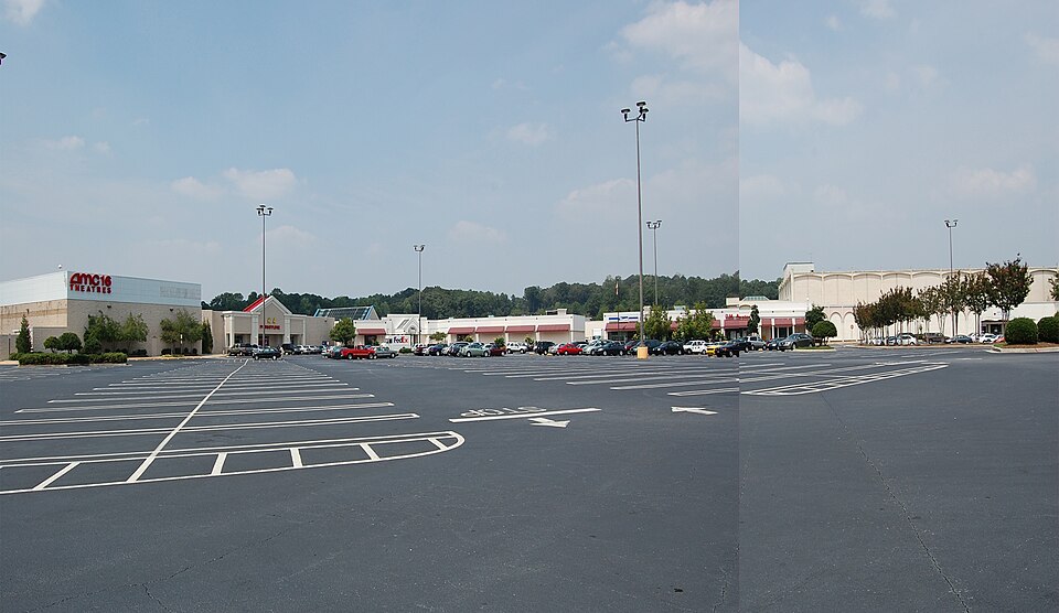
North DeKalb Mall was an enclosed shopping mall located in unincorporated DeKalb County, near Decatur, a suburb of Atlanta, Georgia, United States. Opened in 1965, the center currently comprises more than eighty-five stores on one level. The sole remaining anchor store is Marshalls. That store and an AMC multiplex theater still remain. The rest of the mall was demolished in the summer of 2024 and is being replaced with a mixed-use development called Lulah Hills.
Excerpt from Wikipedia (authors and history), CC BY-SA 4.0. May be older than the record above.
Timeline
- 1965 Opened (Wikidata)
- 1965 Opened with fifty-four stores; original anchors Rich's and Woolworth.
- 1986 Expanded with anchors Mervyn's and Lechmere; renamed Market Square at North DeKalb.
- 1997 Mervyns closed; store replaced by Uptons then Burlington.
- 2014 Lennar and Sterling Organization purchased mall for undisclosed amount, planning open-air conversion.
- 2016 Macy's anchor closed.
- 2019 Property sold to Edens for planned mixed-use development.
- 2020 Mall officially closed due to poor sales and COVID-19; Marshalls and AMC remain open.
- 2022 Local journalists obtained preliminary site plans via public records request.
- 2023 Retrofit: redevelop
- 2024 Demolition began; site being redeveloped as Lulah Hills.
Sources
- Wikipedia · supports: status, year closed
12 quoted sentences
As of October 1, 2020, North DeKalb Mall had officially closed due to poor sales and the impact of the COVID-19 pandemic.
The rest of the mall was demolished in the summer of 2024 and is being replaced with a mixed-use development called Lulah Hills.
Originally and formerly called North DeKalb Center, the mall was designed by Barrett + Associates, Architects, and first opened July 29, 1965, with fifty-four stores; original anchor stores included Atlanta-based department store Rich's, and a Woolworth dime store.
In 1986, North DeKalb Mall was expanded and renovated with two new anchor stores: department store chains Mervyn's and discount chain Lechmere. The mall was renamed Market Square at North DeKalb at this time.
- DeKalb County · supports: zoning change
1 quoted sentence
Edens says it received unanimous approval on the landmark rezoning from the DeKalb County Board of Commissioners in Summer 2022.
- edens.com
- The Atlanta Journal-Constitution · 2025-12
- Crescent Communities · 2025-12
More in Georgia
 Phipps PlazaAtlanta, GA · 2018Partial Redeveloped · Partial redevelopment, mixed use