Malls · Massachusetts
Shopper's World
Opened 1995. Closed 1994. Redeveloped in 1994.
Solid = from the authors' map · outlined = public source · dashed = model-written, not yet reviewed by a person. Tap any value's source label to see where it came from.
Site profile16 elements · what this retrofit is built with · tap a chip for the evidence
Jordan Marsh
This site: Jordan Marsh wikipedia · all sites with thisOn Facebook
This site: …https://www.facebook.com/1448869991899009 overture · all sites with thisWebsite alive
This site: …https://locations.uedge.com/shoppers-world overture / http check · all sites with this15-minute neighbourhood (5+ of 6 daily needs within 800 m)
This site: 6/6 openstreetmap · all sites with this3+ other atlas sites within 10 km
This site: 6 within 10 km computed · all sites with this30,000+ vehicles a day on an adjacent road
This site: 51,094 on a counted road fhwa-hpms · all sites with thisBike network nearby
This site: 11 ways openstreetmap · all sites with thisCounty lost 10%+ of retail establishments since 2012
This site: -10% census-cbp · all sites with thisCounty permitting 2,000+ apartment units a year
This site: 2,440 units, Middlesex County census-bps · all sites with thisCounty typical rent $2,000+
This site: $3,069/mo zillow · all sites with thisGrocery within 800 m
This site: 2 stores openstreetmap · all sites with thisHigh-income tract ($100k+)
This site: $113,764 census-acs · all sites with thisTract income up 60%+ since 2013
This site: +64% census-acs · all sites with thisWalkable block group (EPA ≥ 12)
This site: …index 17 epa-walkability · all sites with thisRedeveloped
This site: …open-air shopping center extraction · all sites with thisRetail (continued)
This site: …open-air shopping center extraction · all sites with thisNow
| Status | Operatingextracted, unreviewed |
|---|---|
| Strategy | Redevelopedextracted, unreviewed |
| New uses | retailextracted, unreviewed |
| What is there now | open-air shopping centerextracted, unreviewed |
| Retrofit year | 1994extracted, unreviewed |
Site context
| FEMA flood zone | X · AREA OF MINIMAL FLOOD HAZARDFEMA NFHL |
|---|---|
| EPA-regulated facilities within 500 m | 28: BANFIELD PET HOSPITAL 1582; BANFIELD PET HOSPITAL 5273; BARMAKIAN JEWELERS; BED BATH AND BEYOND 0109; BEST BUY STORE #532EPA FRS |
| Census tract 25017383600 | 6,046 people, 2,537 per sq mi; median household income $113,764; median gross rent $1,915; 31% renters; 3.4% vacant units; 1.4% commute by transitACS 2023 5-year |
| Walkability (EPA, block group) | index 17 of 20; 117 intersections per sq mi; nearest transit stop 220 m; land-use mix 0.83; 164,251 jobs within 45 min by car, 12,843 by transit; 0% of households without a carEPA Smart Location |
| Within a 10–15 minute walk (800 m) | 6 of 6 daily needs: 2 grocers, 1 schools, 1 parks or playgrounds, 2 health, 1 civic, 28 food and drink; 11 cycleway segments, 126 sidewalk-tagged segmentsOpenStreetMap |
| Opportunity Zone | noHUD |
| Housing permits, Middlesex County (MA), 2024 | 2,440 units in 5+ unit buildings, 166 in 2–4, 889 single-family; 2023: 2,902 in 5+Census BPS |
| Social vulnerability (CDC SVI 2022, tract) | overall percentile 0.64; socioeconomic 0.40; housing and transport 0.78; 11% below 150% of poverty; 5% of households with no vehicleCDC/ATSDR |
| Other atlas sites nearby | 6 within 10 km, 18 within 25 km: Nouvelle at Natick (0.9 km); Natick Mall (0.9 km); Framingham Mall (3.1 km); Shoppers World (3.3 km); Dennison Building Complex (3.3 km)computed |
| Overture Maps | place Shoppers World (shopping_mall, confidence 0.98, from Overture, Overture-signals, meta); building footprint 4,795 m², 10.1 mOverture (CDLA-Permissive 2.0) |
| Website and social | locations.uedge.com (alive) · social: facebookOverture / Internet Archive |
| Attention: Wikipedia page views | 133,714 since 2015; 5,828 in the last 12 months (+9% vs the prior 12); peak 2016-01 with 11,838Wikimedia |
| Tract change 2013–2023 | population -1% (6,083 → 6,046); median income +64% ($69,410 → $113,764); renters 44% → 30%; median home value +66% ($363,000 → $602,900)Census ACS 5-year |
| Natural hazard risk (FEMA National Risk Index, tract) | relatively low overall (score 37.8); expected annual loss $1.2M; high: ice storm; community resilience very highFEMA NRI |
| Tax-credit housing within 1 km | noneHUD LIHTC |
| Retail trade in the county, 2012 to 2023 | 4,650 establishments (-10%); 79,115 jobs (-5%)Census CBP |
| Housing market in the county | typical home value $804,837 (+2% 1 yr, +22% 5 yr); typical rent $3,069/mo (+2% 1 yr), 2026-09Zillow Research |
| House price index, tract, 2025 | 743 (2000 = 100); +6.6% 1 yr, +51% 5 yr, +90% 10 yrFHFA |
| Traffic on the busiest road within 600 m (2024) | 51,094 vehicles a day (principal arterial, 6 lanes); 2,760 trucks; 30 counted segmentsFHWA HPMS |
Summary, model-written
Shopper's World originally opened in 1951 as a suburban mall with 44 stores. The original structure was demolished in 1994 and replaced by an open-air shopping center, which reopened in 1995. The site continues to operate today as an open-air retail center.
Why. The record shows the original mall was demolished and replaced, indicating a retrofit driven by obsolescence or market shifts; no explicit anchor loss, competition, or debt is cited.
Where it stands. The site is currently operating as an open-air shopping center under the ownership of DDR Corp.
For a planner
- Redevelopment strategy already executed (retrofit built 1994) with new use as retail.
- Large site size (795,308 sq ft GLA) noted as a factor in opportunity scoring.
- Open questions include long‑term viability given median rent $2,126 and lack of detailed policy tools or entitlement updates.
For a developer
- Site size: 795,308 sq ft GLA.
- Control: single owner DDR Corp.; status operating.
- Entitlement stage: retrofit completed 1994; no further entitlement noted.
- Constraints: floodplain, transit access, and environmental conditions are not specified in the record.
- Market signal: median rent reported as $2,126; opportunity score 0.0 reflects built‑out condition.
What we do not know yet
- Inconsistent dates: year_opened 1995 conflicts with event timeline showing 1951 opening.
- Year_closed 1994 precedes year_opened, suggesting data error.
- Key details on anchor tenants, competition, debt, or financing are not provided.
- Context‑layer constraints (flood, transit, environment) are missing.
- Verification status is "draft" and several fields (year_closed, year_retrofit, after_notes, status, strategy, new_use) are marked as extraction and unreviewed.
Generated by nvidia/nemotron-3-super-120b-a12b on NVIDIA API via Hermes CT from the fields, parcels, deals and context layers on this page, with no outside knowledge. It is regenerated when the record changes and has not been checked by a person. How it is made.
Similar sites
- City Center, Columbus, OH · Malls · similar GLA (958,000 sq ft); opened 1989; same strategy: redevelop
- Bellevue Mall, Nashville, TN · Malls · similar GLA (844,124 sq ft); opened 1990; same strategy: redevelop
- Shoppers World, Framingham, MA · Malls · closed 1994; same strategy: redevelop; also in MA
- Natick Mall, Natick, MA · Malls · same strategy: redevelop; also in MA; 1 km away
Elsewhere on the web
Pages with photos
- Shopper's World logo commons.wikimedia.org
- Ye Olde Shopper's World, Framingham, MA youtube.com
- Shopper's World - The World's Largest Suburban Shopping Cente… cardcow.com

Search images: Google · Bing · Commons · references: ULI case studies · Google Scholar
Multifamily screen
- retrofit already built
- 795,308 sq ft GLA (large site)
- median rent $2,126
Inputs: record fields (size, status) and county Census ACS 2018–2023 figures (growth, rent). How the points work. Not a recommendation.
History and original facts
| Opened | 1995Esri 2014 layer |
|---|---|
| Closed | 1994extracted, unreviewed |
| Gross leasable area | 795,308 sq ftEsri 2014 layer |
| Stores at peak | 25Esri 2014 layer |
| Anchors | Kohl's, Marshalls, General Cinema, Best Buy, Jordan Marsh |
| Organisations in Wikidata (undated) | DDR Corp. |
| Address | Worcester Rd. (Rt. 9) & Cochituate Rd. (Rt. 3 |
| County | Middlesex |
| Census division | 1 · New England |
| Notes | Wikipedia categories: Demolished shopping malls in the United States |
Not yet recorded: acres, original developer. Know it? Tell us.
Background
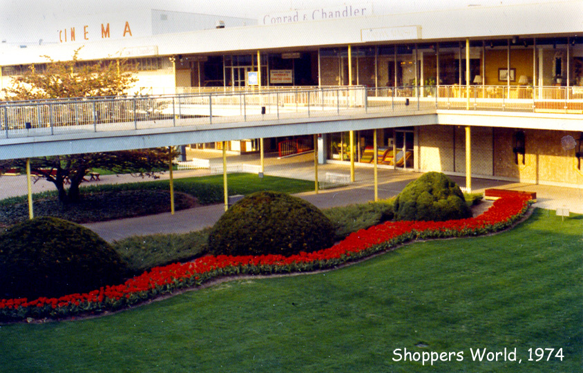
Shopper's World is an open-air shopping center in Framingham, Massachusetts. The original facility is of historical significance as one of the first suburban shopping malls in the United States upon opening in 1951; though it had a central courtyard and covered walkways, it was not fully indoor. The original structure was demolished and replaced by the current open-air facility in 1994. The retail park, with the adjacent Natick Mall in Natick, are major components of the Golden Triangle shopping district in the center of MetroWest, situated between Route 9 and Route 30.
Excerpt from Wikipedia (authors and history), CC BY-SA 4.0. May be older than the record above.
Timeline
- 1951 Opened with 44 stores
- 1961 Stop & Shop grocery store built
- 1963 Cinema added second theater
- 1967 Jordan Marsh Basement Store built
- 1974 Cinema added two more theaters
- 1975 First two auditoriums split, Cinema reaches 6 screens
- 1985 Gazebo area constructed
- 1994 Original structure demolished and replaced by current open-air facility
- 1995 Opened
Sources
- Wikipedia: Shopper's World · supports: after notes, status, strategy, year closed
12 quoted sentences
The original structure was demolished and replaced by the current open-air facility in 1994.
Shopper's World is an open-air shopping center in Framingham, Massachusetts.
Shopper's World is an open-air shopping center in Framingham, Massachusetts.
The original structure was demolished and replaced by the current open-air facility in 1994.
- Esri StoryMaps: Closed_US_Malls feature layer (2014) · 2014-10-02
More in Massachusetts
 Worcester GalleriaWorcester, MA · 2010Redeveloped · Redevelopment: mixed use, new streets