Malls · New York
Mohawk Mall
Opened 1970. Closed 2000. Redeveloped.
documented
It was first opened in 1970 and mostly demolished in 2000, with its last remaining section demolished in 2002.
documented
Mohawk Mall was an enclosed shopping mall in the town of Niskayuna, New York, on a 50-acre (200,000 m2) parcel located at the corner of State Street and Balltown Road.
Solid = from the authors' map · outlined = public source · dashed = model-written, not yet reviewed by a person. Tap any value's source label to see where it came from. documented = a quoted excerpt (click to read it) · reported = a source named, no excerpt yet · no source.
Site profile13 elements · what this retrofit is built with · tap a chip for the evidence
Bradlees
This site: Bradlees wikipedia · all sites with thisMontgomery Ward
This site: Montgomery Ward wikipedia · all sites with thisOn Facebook
This site: …https://www.facebook.com/1562860357265203 overture · all sites with thisWebsite alive
This site: …http://iamawesome.com/ overture / http check · all sites with thisSingle-purpose entity
This site: American Real Estate Holdings Ltd. Partners county-parcels · all sites with this15-minute neighbourhood (5+ of 6 daily needs within 800 m)
This site: 5/6 openstreetmap · all sites with thisCounty lost 10%+ of retail establishments since 2012
This site: -10% census-cbp · all sites with thisGrocery within 800 m
This site: 3 stores openstreetmap · all sites with thisHigh-income tract ($100k+)
This site: $113,811 census-acs · all sites with thisLow social vulnerability tract (SVI ≤ 0.25)
This site: 0.21 cdc-svi · all sites with thisRedeveloped
This site: Mohawk Commons, a lifestyle center extraction · all sites with thisMixed use
This site: Mohawk Commons, a lifestyle center extraction · all sites with thisRetail (continued)
This site: …new_use field extraction · all sites with thisNow
| Status | Demolishedextracted, unreviewed documentedIt was first opened in 1970 and mostly demolished in 2000, with its last remaining section demolished in 2002. |
|---|---|
| Strategy | Redevelopedextracted, unreviewed documentedThe property has been redeveloped into Mohawk Commons, a lifestyle center. |
| New uses | retailextracted, unreviewed reported |
| What is there now | Mohawk Commons, a lifestyle centerextracted, unreviewed documentedThe property has been redeveloped into Mohawk Commons, a lifestyle center. |
Site context
| FEMA flood zone | X · AREA OF MINIMAL FLOOD HAZARDFEMA NFHL |
|---|---|
| EPA-regulated facilities within 500 m | 9: GETTY PETROLEUM CORP; GOODYEAR TIRE & RUBBER CO; LOWES OF NISKAYUNA NY #1612; METRO FORD; MOBIL OIL CORP SS #JL5EPA FRS |
| Census tract 36093031902 | 3,061 people, 1,767 per sq mi; median household income $113,811; median gross rent $1,083; 30% renters; 12.9% vacant units; 0.0% commute by transitACS 2023 5-year |
| Within a 10–15 minute walk (800 m) | 5 of 6 daily needs: 3 grocers, 0 schools, 2 parks or playgrounds, 1 health, 1 civic, 13 food and drink; 0 cycleway segments, 2 sidewalk-tagged segmentsOpenStreetMap |
| Opportunity Zone | noHUD |
| Housing permits, Schenectady County (NY), 2024 | 54 units in 5+ unit buildings, 22 in 2–4, 78 single-family; 2023: 8 in 5+Census BPS |
| Social vulnerability (CDC SVI 2022, tract) | overall percentile 0.21; socioeconomic 0.04; housing and transport 0.60; 5% below 150% of poverty; 16% of households with no vehicleCDC/ATSDR |
| Other atlas sites nearby | 1 within 10 km, 8 within 25 km: Northway Mall (9.2 km)computed |
| Overture Maps | place Mohawk Mall (shopping_mall, confidence 0.95, from Overture, meta); building footprint 6,584 m², 6.994510650634766 mOverture (CDLA-Permissive 2.0) |
| Website and social | iamawesome.com (alive) · social: facebookOverture / Internet Archive |
| Attention: Wikipedia page views | 28,576 since 2015; 2,159 in the last 12 months (-3% vs the prior 12); peak 2018-01 with 815Wikimedia |
| Tract change 2013–2023 | tract boundary changed between the 2010 and 2020 census; no 2013 comparisonCensus ACS |
| Natural hazard risk (FEMA National Risk Index, tract) | very low overall (score 9.2); expected annual loss $429,844; community resilience very highFEMA NRI |
| Tax-credit housing within 1 km | noneHUD LIHTC |
| Retail trade in the county, 2025 (BLS QCEW) | 6,965 jobs in 432 establishments; average annual pay $49,009; employment location quotient 1.17; employment -0.3% on the yearBLS QCEW 2025, NAICS 44-45, private |
| Jobs located in the tract, 2022 | 2,154 jobs; 1,185 in retail trade, 282 in accommodation and food (workplace blocks summed to tract 36093031902)Census LEHD LODES8 WAC 2022 |
| Upward mobility (Opportunity Atlas, 2010 tract) | children of low-income (25th percentile) families reached the 50th income percentile as adults; 0.5% incarcerated at the 2010 count (265 children in the sample); born 1978–83, measured 2014–15Opportunity Insights |
| Food access (USDA FARA 2019, 2010 tract) | low-access at 1 mile, not low-income; 51% of residents more than 1 mile from a supermarket; poverty rate 5.0%; median family income $120,766; 59 SNAP householdsUSDA ERS |
| Schools | South Colonie Central School District (PK-12); 1 public school within 1 mile: WOODLAWN ELEMENTARY SCHOOLNCES EDGE |
| Elevation | 382 ft above sea level at the site pointUSGS 3DEP |
| Storm events in the county, 2016-2025 | 151 county-logged events: 106 thunderstorm wind, 18 flood, 10 flash flood, 10 hail; $341,000 property damage reported; forecast-zone events (most flood, winter and heat) not countedNOAA Storm Events |
| Homes for sale in ZIP 12304, 2026-09 | median list price $279,675 (+6.1% on the year); 33 active listings; median 31 days on market; 17% with a price cutRealtor.com Research |
| Retail trade in the county, 2012 to 2023 | 432 establishments (-10%); 7,298 jobs (-1%)Census CBP |
| Housing market in the county | typical home value $312,933 (+5% 1 yr, +34% 5 yr); typical rent $1,499/mo (+3% 1 yr), 2026-09Zillow Research |
| House price index, tract, 2025 | 256 (2000 = 100); +5.1% 1 yr, +49% 5 yr, +64% 10 yrFHFA |
| Traffic on the busiest road within 600 m (2024) | 15,988 vehicles a day on 5 (principal arterial, 4 lanes); 739 trucks; 33 counted segmentsFHWA HPMS |
Summary, model-written
Mohawk Mall opened in 1970 on a 50‑acre site in Niskayuna, NY, operated by Genesee Management and changed ownership several times. After anchor store closures (e.g., Boston Store in 1990) and declining performance, the mall was mostly demolished in 2000 with the final section removed in 2002. The property was redeveloped into Mohawk Commons, a lifestyle center.
Why. The record shows anchor loss (Boston Store closure) and multiple ownership shifts, but does not explicitly cite competition, debt, or demolition causes; thus causes are not stated beyond the closure and redevelopment.
Where it stands. The site is now demolished and redeveloped as Mohawk Commons; the latest recorded owner from the parties list is American Real Estate Holdings Ltd. Partners (from 1998 onward), though current control is not specified.
For a planner
- Precedent: conversion of an enclosed mall to a lifestyle center (Mohawk Commons).
- Policy tools: none mentioned in the record.
- Open questions: what zoning or incentives facilitated the redevelopment; what environmental review was required.
For a developer
- Site size: 50 acres.
- Control: ownership history shows multiple parties; latest known owner is American Real Estate Holdings Ltd. Partners (1998‑present).
- Entitlement stage: redeveloped into lifestyle center, implying approvals completed.
- Constraints: record does not provide flood, transit, or environmental context layers.
What we do not know yet
- Missing data on flood risk, transit access, and environmental constraints.
- No explicit market signals or tract‑level demographics provided.
- Ownership after 1998 is unclear; current controlling entity not confirmed.
- Demolition timeline details beyond 2002 are not detailed.
- Some fields (e.g., strategy, new_use) are model‑extracted and marked as extraction without verification.
Generated by nvidia/nemotron-3-super-120b-a12b on NVIDIA API via Hermes CT from the fields, parcels, deals and context layers on this page, with no outside knowledge. It is regenerated when the record changes and has not been checked by a person. How it is made.
Similar sites
- Saratoga Mall, Wilton, NY · Malls · similar size (45 acres); opened 1973; closed 1999
- Methuen Mall, Methuen, MA · Malls · similar size (60 acres); opened 1973; closed 1997
- North Kent Mall, Northview, MI · Malls · similar size (70 acres); opened 1970; closed 2000
- Northridge Mall, Milwaukee, WI · Malls · similar size (58 acres); opened 1973; closed 2003
Elsewhere on the web
Pages with photos
- Mohawk Mall Shopping Center Map - New York - Mapcarta mapcarta.com
- Mohawk Mall: Image 52 of 53 deadmalls.com
Search images: Google · Bing · Commons · references: ULI case studies · Google Scholar
Multifamily screen
- closed or demolished site (sourced)
- 50 acres
- county grew 3.0% 2018–23
Inputs: record fields (size, status) and county Census ACS 2018–2023 figures (growth, rent). How the points work. Not a recommendation.
History and original facts
| Opened | 1970Wikidata |
|---|---|
| Closed | 2000Wikidata reported |
| Acres | 50.0extracted, unreviewed documentedMohawk Mall was an enclosed shopping mall in the town of Niskayuna, New York, on a 50-acre (200,000 m2) parcel located at the corner of State Street and Balltown Road. |
| Stores at peak | 73extracted, unreviewed reported |
| Original developer | Stanford Associatesextracted, unreviewed documentedIt was constructed by Stanford Associates and designed by Evantash-Friedman Associates of Philadelphia. |
| Architect | Evantash-Friedman Associates of Philadelphia |
| Anchors | Montgomery Ward, J.M. Fields, Bradlees, Boston Store |
| County | Schenectady County |
| Census division | 2 · Mid-Atlantic |
| Notes | Wikipedia categories: Demolished shopping malls in the United States |
Not yet recorded: GLA, retrofit year. Know it? Tell us.
Background
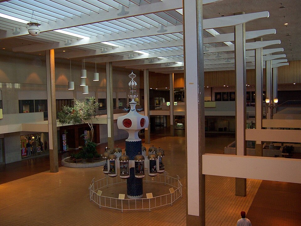
Mohawk Mall was an enclosed shopping mall in the town of Niskayuna, New York, on a 50-acre (200,000 m2) parcel located at the corner of State Street and Balltown Road. It was managed by Genesee Management. It had three courts with groups of fountains and seating areas. The mall was first opened in 1970 and mostly demolished in 2000, with its last remaining section demolished in 2002. The property has been redeveloped into Mohawk Commons, a lifestyle center.
Excerpt from Wikipedia (authors and history), CC BY-SA 4.0. May be older than the record above.
Timeline
- 1970 Opened (Wikidata)
- 1970 Mall opened
- 1972 Stanford Associates identified as owner of middle of mall
- 1976 Mall purchased by Balcor Realty Investors, Ltd.
- 1983 Wilmorite purchased center section of mall
- 1990 Boston Store closed
- 1998 Ownership details reported by Albany Business Journal
- 2000 Closed (Wikidata)
- 2000 Mall mostly demolished
- 2002 Last remaining section demolished
Sources
- Wikipedia: Mohawk Mall · supports: acres, after notes, original developer, status, strategy
13 quoted sentences
Mohawk Mall was an enclosed shopping mall in the town of Niskayuna, New York, on a 50-acre (200,000 m2) parcel located at the corner of State Street and Balltown Road.
It was constructed by Stanford Associates and designed by Evantash-Friedman Associates of Philadelphia.
The property has been redeveloped into Mohawk Commons, a lifestyle center.
It was first opened in 1970 and mostly demolished in 2000, with its last remaining section demolished in 2002.
More in New York
 Midtown PlazaRochester, NY · 2005Partial Redeveloped · Regreened · Reinhabited · Partial reinhabitation: residential Partial redevelopment: office…
 Rainbow MallNiagara Falls, NY · 2012Partial Reinhabited · Partial reinhabitation: education