Malls · Ohio
Randall Park Mall
Opened 1976, closed 2009, demolished 2015‑2017, Amazon fulfillment center built 2018 on 64‑acre site with public subsidies, pending zoning clarification. · summary, model-written
Solid = from the authors' map · outlined = public source · dashed = model-written, not yet reviewed by a person. Tap any value's source label to see where it came from. documented = a quoted excerpt (click to read it) · reported = a source named, no excerpt yet · no source.
Site profile16 elements · what this retrofit is built with · tap a chip for the evidence
Dillard's
This site: Dillard's wikipedia · all sites with thisMacy's
This site: Macy's wikipedia · all sites with thisSears
This site: Sears wikipedia · all sites with thisSingle-purpose entity
This site: AZ RANDALL OH LANDLORD, LLC county-parcels · all sites with thisCounty lost 10%+ of retail establishments since 2012
This site: -10% census-cbp · all sites with thisGrocery within 800 m
This site: 6 stores openstreetmap · all sites with thisHigh social vulnerability tract (SVI ≥ 0.75)
This site: 0.81 cdc-svi · all sites with thisLower-income tract (< $50k)
This site: $43,986 census-acs · all sites with thisOpportunity Zone
This site: 39035193800 hud-oz · all sites with thisRenter-majority tract
This site: 70% census-acs · all sites with thisShrinking county
This site: -0.3% census-acs · all sites with thisBonds
This site: …er); zoning not found Port Authority $123M in taxable lease bonds; Ohio job-creation tax credit of about $7.8M (1.35%, 10 yea research-planning · all sites with thisTax abatement or incentive
This site: …t Authority $123M in taxable lease bonds; Ohio job-creation tax credit of about $7.8M (1.35%, 10 years). Approved by Cleveland-Cuy research-planning · all sites with this1M+ sq ft GLA
This site: 1,588,500 sq ft esri-closed-us-malls-2014 · all sites with this60+ acre site
This site: 64 acres research-planning · all sites with thisBuilding footprint 50,000+ m²
This site: 78,470 m² overture · all sites with thisNow
| Status | Status not verifiedWikidata reported |
|---|---|
| Redeveloper | Amazon (via developer)research reported |
| Owner of record | Az Randall Oh Landlord, LLCcounty assessor reported |
Planning
| Zoning change | industrial reuse (Amazon fulfillment center); zoning not foundresearch documentedThe Port Authority has committed $123 million in taxable lease bonds to create the 855,000 square foot fulfillment center. |
|---|---|
| Public purchase or subsidy | Port Authority $123M in taxable lease bonds; Ohio job-creation tax credit of about $7.8M (1.35%, 10 years).research reported |
| Entitlement year | 2017research reported |
| Planning notes | Approved by Cleveland-Cuyahoga County Port Authority; Ohio Tax Credit Authority; North Randall village. research reported |
Parcels, tax and title
| Parcel | Owner of record | Acres | Use · zoning | Value (appraised · assessed · taxable) | Last sale · deed | ||||||||||||||||||||||||||||||||||||||||||||||||||||||||||||||||||||||||||||||||||||||||||||||||||||||||||||||||||||||||||||||||||||||||
|---|---|---|---|---|---|---|---|---|---|---|---|---|---|---|---|---|---|---|---|---|---|---|---|---|---|---|---|---|---|---|---|---|---|---|---|---|---|---|---|---|---|---|---|---|---|---|---|---|---|---|---|---|---|---|---|---|---|---|---|---|---|---|---|---|---|---|---|---|---|---|---|---|---|---|---|---|---|---|---|---|---|---|---|---|---|---|---|---|---|---|---|---|---|---|---|---|---|---|---|---|---|---|---|---|---|---|---|---|---|---|---|---|---|---|---|---|---|---|---|---|---|---|---|---|---|---|---|---|---|---|---|---|---|---|---|---|---|---|---|---|---|
77105009all 104 county fields
| Az Randall Oh Landlord, LLC | 65.8 | DISTRIBUTION WHSE · C-1 | $26.1M (appraised) assessed $9.1M | 2017-08-28 | ||||||||||||||||||||||||||||||||||||||||||||||||||||||||||||||||||||||||||||||||||||||||||||||||||||||||||||||||||||||||||||||||||||||||
| Total | 65.8 | $26.1M |
Site context
| Transit within 800 m | no rail stationOpenStreetMap |
|---|---|
| Motorway junctions within 2 km | 1, 25A, 25A-B-C, 25BOpenStreetMap |
| FEMA flood zone | X · AREA OF MINIMAL FLOOD HAZARDFEMA NFHL |
| EPA-regulated facilities within 500 m | 5: ALLIED DECALS INC; GOODYEAR 0557; NORTH RANDALL NORTHFIELD LLC; SHERWIN-WILLIAMS #1058; WHITE CAP DBA FORM TECHEPA FRS |
| Census tract 39035197000 | 3,171 people, 1,491 per sq mi; median household income $43,986; median gross rent $1,000; 70% renters; 4.1% vacant units; 5.0% commute by transitACS 2023 5-year |
| Within a 10–15 minute walk (800 m) | 3 of 6 daily needs: 6 grocers, 1 schools, 0 parks or playgrounds, 0 health, 0 civic, 8 food and drink; 0 cycleway segments, 118 sidewalk-tagged segmentsOpenStreetMap |
| Opportunity Zone | yes, tract 39035193800 (rural)HUD |
| Housing permits, Cuyahoga County (OH), 2024 | 920 units in 5+ unit buildings, 102 in 2–4, 663 single-family; 2023: 735 in 5+Census BPS |
| Social vulnerability (CDC SVI 2022, tract) | overall percentile 0.81; socioeconomic 0.84; housing and transport 0.63; 30% below 150% of poverty; 10% of households with no vehicleCDC/ATSDR |
| Other atlas sites nearby | 2 within 10 km, 10 within 25 km: City View Center (7.4 km); Severance Center (9.5 km)computed |
| Overture Maps | no place match; building footprint 78,470 m²Overture (CDLA-Permissive 2.0) |
| Attention: Wikipedia page views | 323,158 since 2015; 17,331 in the last 12 months (-5% vs the prior 12); peak 2017-08 with 8,094Wikimedia |
| Tract change 2013–2023 | tract boundary changed between the 2010 and 2020 census; no 2013 comparisonCensus ACS |
| Natural hazard risk (FEMA National Risk Index, tract) | relatively low overall (score 34.7); expected annual loss $880,689; community resilience very highFEMA NRI |
| Tax-credit housing within 1 km | noneHUD LIHTC |
| Retail trade in the county, 2025 (BLS QCEW) | 54,041 jobs in 3,980 establishments; average annual pay $38,612; employment location quotient 0.79; employment -0.9% on the yearBLS QCEW 2025, NAICS 44-45, private |
| Jobs located in the tract, 2022 | 13,169 jobs; 542 in retail trade, 82 in accommodation and food (workplace blocks summed to tract 39035197000)Census LEHD LODES8 WAC 2022 |
| Upward mobility (Opportunity Atlas, 2010 tract) | children of low-income (25th percentile) families reached the 30th income percentile as adults; 6.9% incarcerated at the 2010 count (87 children in the sample); born 1978–83, measured 2014–15Opportunity Insights |
| Food access (USDA FARA 2019, 2010 tract) | not a low-access tract at 1 mile; poverty rate 19.9%; median family income $43,583; 90 SNAP householdsUSDA ERS |
| Schools | Warrensville Heights City School District (PK-12); 5 public schools within 1 mile: Randall Park High School; Warrensville Heights High School; Warrensville Heights Middle School; Warrensville Heights Elementary SchoolNCES EDGE |
| Elevation | 1,048 ft above sea level at the site pointUSGS 3DEP |
| Storm events in the county, 2016-2025 | 307 county-logged events: 199 thunderstorm wind, 48 hail, 46 flash flood, 8 flood; $38,727,500 property damage reported; forecast-zone events (most flood, winter and heat) not countedNOAA Storm Events |
| Homes for sale in ZIP 44128, 2026-09 | median list price $119,900 (+0.3% on the year); 86 active listings; median 52 days on market; 27% with a price cutRealtor.com Research |
| Retail trade in the county, 2012 to 2023 | 3,890 establishments (-10%); 67,128 jobs (+11%)Census CBP |
| Housing market in the county | typical home value $218,659 (+3% 1 yr, +32% 5 yr); typical rent $1,413/mo (+5% 1 yr), 2026-09Zillow Research |
| House price index, tract, 2023 | 142 (2000 = 100); +10.1% 1 yr, +50% 10 yrFHFA |
| Traffic on the busiest road within 600 m (2024) | 28,598 vehicles a day on WARRENSVILLE CENTER RD (minor arterial, 4 lanes); 33 counted segmentsFHWA HPMS |
| Site metrics | appraised value $26.1M on parcels; $408,008 per acre; 24,820 sq ft GLA per acre; FAR 0.57computed |
Summary, model-written
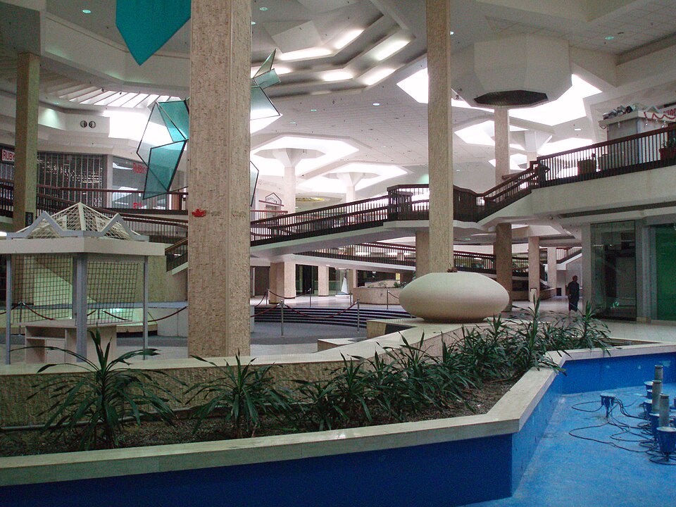
Randall Park Mall opened in 1976 as a super-regional shopping center. After over a decade of decline it closed in March 2009, with the Dillard's store and interior demolished in 2015 and the remaining anchor tenants demolished in 2017. Amazon constructed a distribution center on the site in 2018, converting the property to industrial reuse.
Why. not stated in the record
Where it stands. The site currently hosts an Amazon fulfillment center, with the parcel owned by AZ RANDALL OH LANDLORD, LLC and Amazon acting as the developer/tenant.
For a planner
- Public support included $123M in taxable lease bonds from the Cleveland-Cuyahoga County Port Authority and an Ohio job-creation tax credit of about $7.8M.
- Entitlement was granted in 2017 with approval from the Port Authority, Ohio Tax Credit Authority, and North Randall village.
- Zoning documentation for the industrial reuse is noted as 'not found' in the record, leaving an open question about formal zoning status.
- Long-term viability of the industrial use and any needed infrastructure upgrades remain uncertain.
For a developer
- Site size: approximately 64 acres (parcel shows 65.84 acres).
- Control: owned by AZ RANDALL OH LANDLORD, LLC; developer/tenant is Amazon.
- Entitlement stage: approved in 2017 (entitlement_year).
- Context layers provide yield metrics ($408,008 value per acre, 24,820 GLA per acre, FAR 0.57) but lack specific flood, transit, or environmental constraint data.
- Market signal: opportunity score 25.0 driven primarily by the 64‑acre parcel size.
What we do not know yet
- Current status is listed as 'unknown' in the record despite the narrative describing Amazon's fulfillment center.
- Zoning details for the industrial reuse are missing (zoning not found).
- No information on floodplain, transit access, or environmental constraints is provided.
- Detailed tenant mix, vacancy rates, or employment figures for the Amazon facility are absent.
- The record is marked as 'verified: draft', indicating some data may be model-extracted and unreviewed.
Generated by nvidia/nemotron-3-super-120b-a12b on NVIDIA API via Hermes CT from the fields, parcels, deals and context layers on this page, with no outside knowledge. It is regenerated when the record changes and has not been checked by a person. How it is made.
Similar sites
- Cinderella Mall, Englewood, CO · Malls · similar size (60 acres); similar GLA (1,400,000 sq ft)
- Eastland Mall, Charlotte, NC · Malls · similar size (78 acres); opened 1975
- Exton Square Mall, Exton, PA · Malls · similar size (75 acres); opened 1973
- Newmarket North Mall, Hampton, VA · Malls · similar size (53 acres); opened 1975
Elsewhere on the web
Retail history: Randall Park Mall on DeadMalls.com photos, field notes and visitor memories since 2000; matched by name and state only, check the city; nothing copied here
Pages with photos
- 12 eerie photos of the randall par… artofit.org
- Randall Park Mall - North Randall, OH Gallery - Radically Retro radicallyretro.com
- Randall Park Mall flickr.com
- Randall Park Mall In North Randall, OH: Once The Largest, Now Just A ... bestattractions.org
- Randall Park Mall in the 70s youtube.com
- Images of the abandoned Randall Park Mall dailymail.co.uk
- Trip to the Mall: Randall Park Mall- (North Randall, OH) triptothemall.blogspot.com
Search images: Google · Bing · Commons · references: ULI case studies · Google Scholar
Multifamily screen
- 64 acres
Inputs: record fields (size, status) and county Census ACS 2018–2023 figures (growth, rent). How the points work. Not a recommendation.
History and original facts
| Opened | 1976Wikidata |
|---|---|
| Acres | 64.0research reported |
| Gross leasable area | 1,588,500 sq ftEsri 2014 layer reported |
| Stores at peak | 133Esri 2014 layer reported |
| Anchors | Burlington Coat Factory, Macy's, Dillard's, Sears, Furniture & Mattress |
| Address | IH 480 & IH 271 |
| County | Cuyahoga |
| Census division | 3 · East North Central |
| Notes | Wikipedia categories: Demolished shopping malls in the United States |
Not yet recorded: original developer, what is there now, retrofit year. Know it? Tell us.
Background
Randall Park Mall was a super-regional shopping mall located in the village of North Randall, Ohio, United States. It opened on August 11, 1976 on the site of what used to be the Randall Park Race Track. After over a decade of decline, it closed on March 12, 2009. The former Dillard's store and interior of the mall were demolished in 2015 to make way for an industrial park, and the remaining anchor tenants were demolished in 2017 after they all closed. Amazon built a new distribution center on the site in 2018.
Excerpt from Wikipedia (authors and history), CC BY-SA 4.0. May be older than the record above.
Timeline
- 1976 Opened (Wikidata)
Sources
- ttnews.com · supports: zoning change
1 quoted sentence
The Port Authority has committed $123 million in taxable lease bonds to create the 855,000 square foot fulfillment center.
- cbsnews.com
- icpllc.com
- Esri StoryMaps: Closed_US_Malls feature layer (2014) · 2014-10-02
- Wikipedia: Randall Park Mall · 2026-09-25 · CC BY-SA 4.0
More in Ohio
 Richland MallOntario, OH · 2015Partial Reinhabited · Partial reinhabitation: healthcare